Enniskerry Quakes
A resident report from the heart of the village
New: Visit the Blog for background stories and developments.
Synopsis
Changes in traffic characteristics and deterioration of road conditions in the village have turned into a threat for buildings, support infrastructure and residents. Tremors increasing in frequency and violence compromise the structural integrity of historic, Victorian buildings in the village and are cause for personal injury. This page provides a resident report on the situation at the crossing R117 & Forge Road in Enniskerry village, along with some recommendations for quick wins in an attempt to motivate action to prevent worse from happening.
Purpose & Inteded Audience
This page intends to inform and secure situational evidence in the public domain, primarily to a) enable Bray Municipal to assess the situation and assign the appropriate priority and urgency, b) inform the local community and provide an entrypoint for related experience exchange, c) enable access to evidence for family and friends in case of an incident.
The Problem
Ramps, traffic load and deteriorating road conditions are cause for an increasingly uneven road surface at the village crossing. Vehicles traversing ramps, bumps and manholes are cause for quakes of varying strength, depending on weight, speed and point of impact. Frequency and velocity of the shocks erode affected infrastructure and buildings. With each shock received the structural integrity of the area is further compromised, increasing the risk of structural failure.
Impact
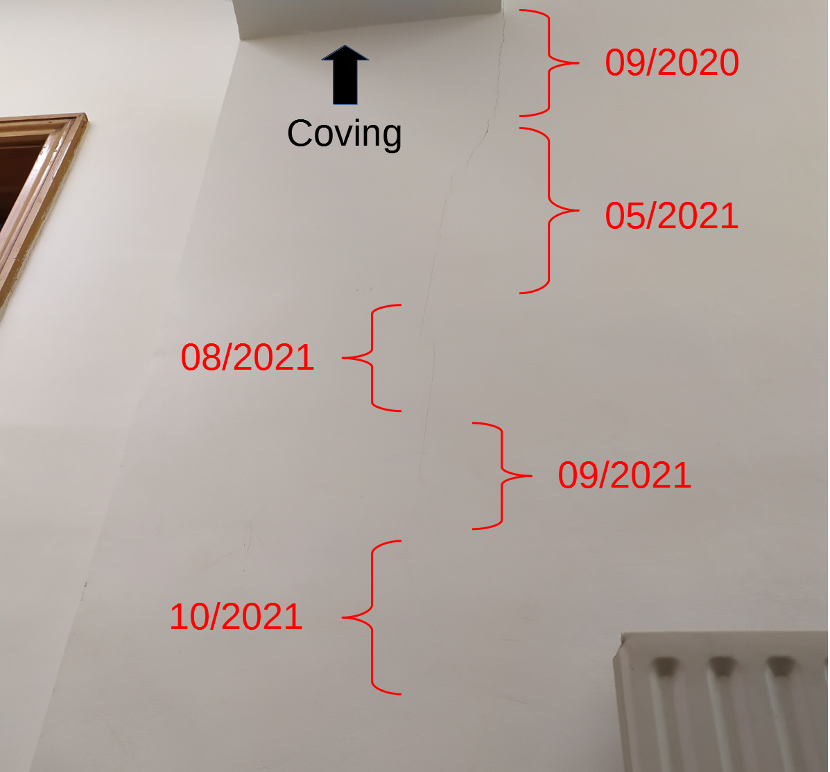
Sample footage of damage caused between 09/2020 - 10/2021. Some cracks are highlighted in red for illustration.
Click on an individual photo for a fullscreen view.
Please consult the High Resolution Photo Gallery (external Link) to inspect additional footage.


Timeline (approx.)
-
03/21: Easing of pandemic restrictions leads to resumption of nearby construction site activity and gradual return to normal schedule for bus routes 44 & 185. Damage to buildings around the crossing becomes visible. Sleep disruption from tremors commences.
-
05/21: Traffic diversion due to filming in Enniskerry (Disenchanted) eases the situation for a few weeks
-
09/21: Moderate to strong quakes caused by traffic become an increasingly regular nuisance and threat. Cracks are forming and expanding on a near daily basis. Children from the nearby primary school need to traverse the crossing twice a day.
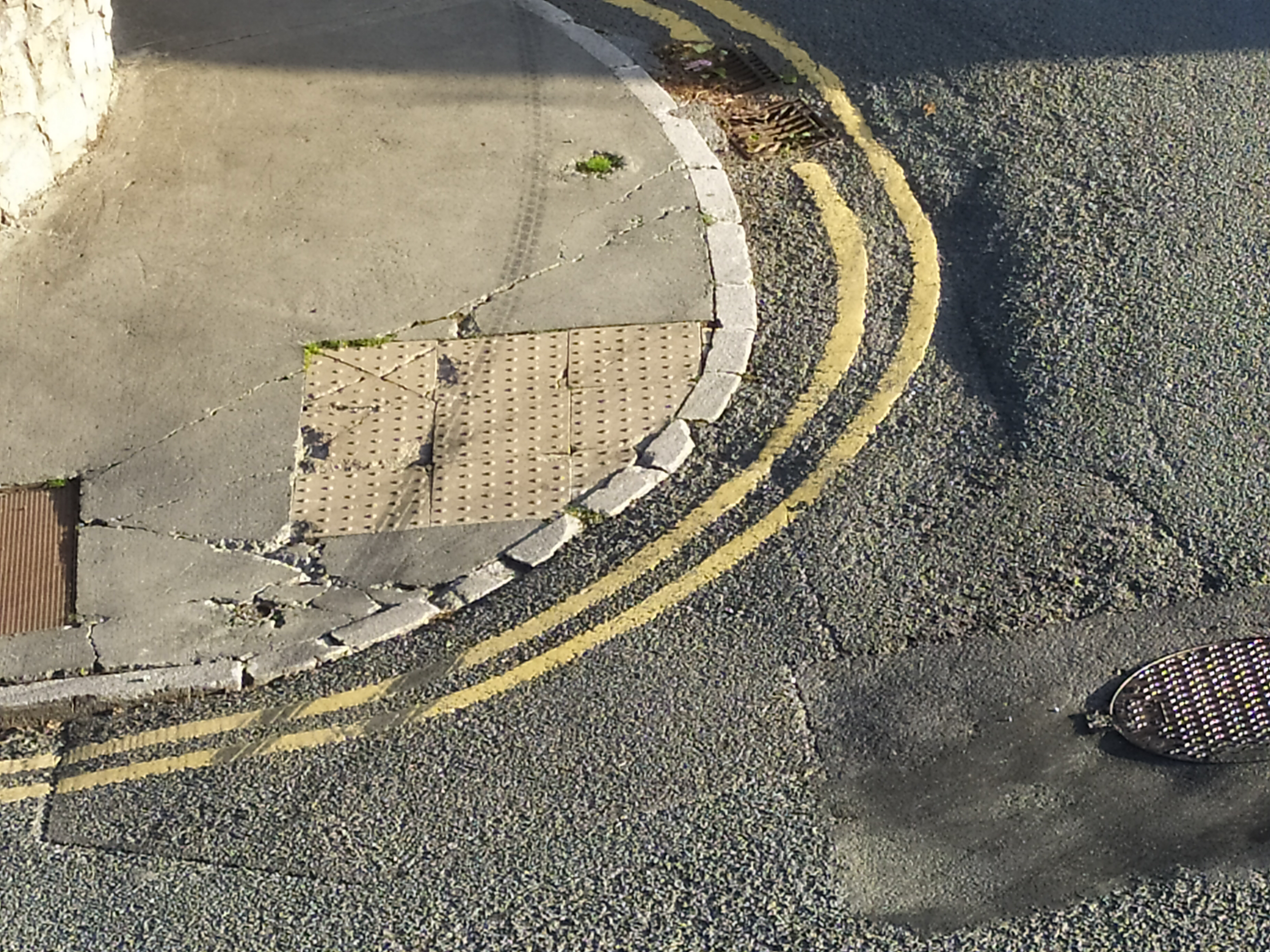
Road condition
-
Ramps(speed bumps) are worn and have become useless (vehicles are speeding over the crossing)
-
Road markings are gone - some ramps as well as uneven/damaged surface are difficult to spot from a drivers position depending on vector of approach and lighting conditions (time of day)
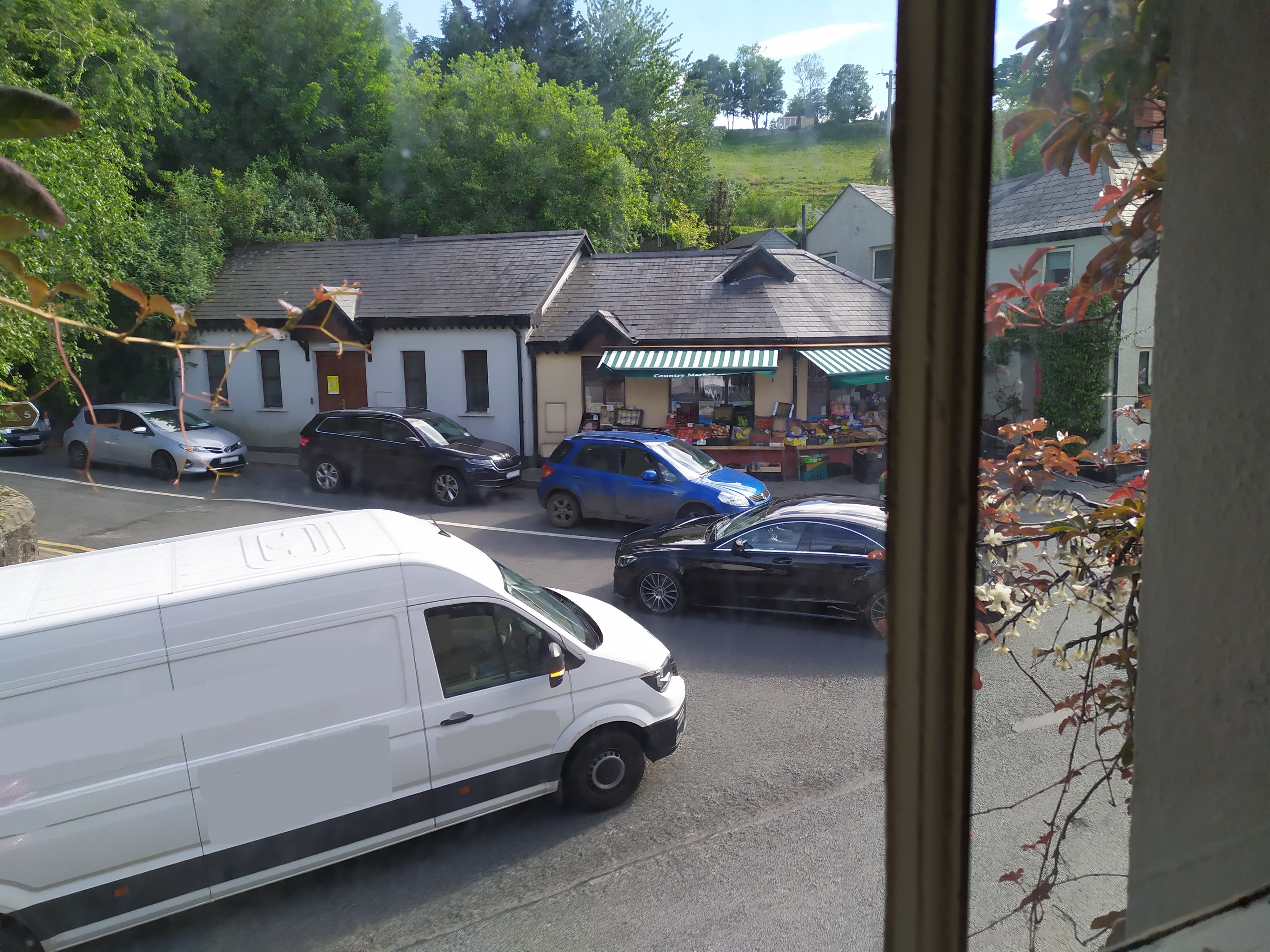
Traffic characteristics
-
Increase in HGV traffic due to nearby construction sites as well as increased night-time activity
-
Will be followed by new residents that have no alternative route to commute to/from their homes
-
Impact depending on driver "enthusiasm"
-
Day- and night-time quakes caused by bus traffic, further depending on speed, velocity, point of impact and vehicle condition
Examples
The following short clips where taken from within a residence at the junction in question. The camera was installed on a stable tripod. There was no movement in the building itself at the time.
Observe how the camera tries to refocus as it gets shaken from the tremors caused by vehicles traversing the ramps at the crossing.
Please turn on audio as you watch these clips
In this first clip the camera receives two shocks: One as the vehicle hits the on-ramp offscreen (0:04), another one as it drops off the ramp in view of the camera (0:10). Observe as well how the ramp itself is barely recognisable in the recordings. From the driver position the ramp is almost indistinguishable (clip 1 - night, clip 2 - driver facing direct sunlight).
Measuring impact and frequency
Disclaimer: The author is neither an expert in seismographic nor with access to professional equipment to measure seismic activity. However, the information presented in this section should be sufficient for trend identificaton as well as for an overall initial assessment.
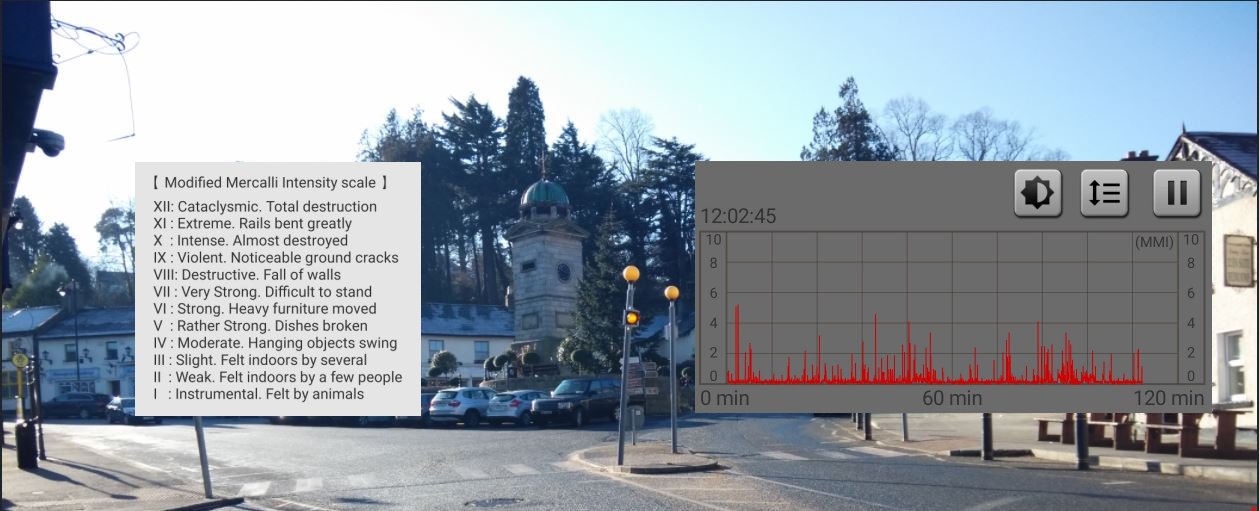
The Modified Mercalli intensity scale is a seismic scale used for measuring the intensity of shaking produced by an earthquake. Whilst limited in their accuracy, consumer applications are available to take measurements against the Mercalli scale e.g. via the sensors of a quality mobile device. The author has taken several measurement in his own residence from late July to September 2021.
The following image contains on the top-left the Mercalli intensity scale itself, on the bottom a measurement over a 2 hour period (approx.). This graph documents that frequent seismic activity is registered in the building. Whilst unlikely due to the setup for the measurements, a magnitude below 2 could still be considered a potential false positive caused by activities in the building. It becomes apparent though that the graph shows record of approx. 30 tremors within a time intervall of two hours, that would classify as an earthquake like seismic event, with four events out of 30 reaching or exceeding level 4 on the Mercalli scale. Whilst this equals two moderate to rather strong earthquakes per hour, the author has experienced up to a dozen such events per hour at peak times.
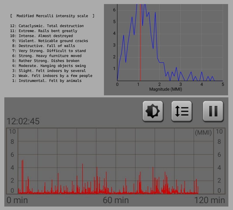
The top-right graph is a statistic displaying the relative distribution of seismic intensity in percent over one of the measurements taken. The disturbing aspect about this statistic is that it documents the occurrence of magnitudes from 3 up to almost 5 on the Mercalli scale.
Structural damage
Disclaimer: The author has no professional expertise in structural engineering
-
Structural damage appearing in every room within a years time
-
Cracks appearing on facade, coving and main wall to adjacent property on the terrace
-
corner-to-corner cracks indicate that the load-bearing walls are separating from the rest of the structure
-
Debris from ceilings and chimney
-
Damage to household items and work equipment
Personal Injury
-
Sleep disruption/deprivation. Example: Timetable of quakes, morning of 27/09: 00:18, 05:40, 06:20, 06:40, 07:20, 07:49
-
Disruption of peace
-
Work disruption (home office)
-
Anxiety - from sounds of crumbling masonry, timber- and pipework
-
Terror - HGV/bus approach turns into a Stuka run - will it hit us or will it pass?
-
Threat - With every moderate quake being a reminder of what could happen, the situation is turning into a constant distraction, impeding performance and wellbeing.
Solution approach & Quick Wins
Disclaimer: The author isn't an expert in traffic management either. Recommendations are limited to experience based common sense approaches.
-
Traffic will continue to increase (more construction work, more residents).
-
No strategy in place to accommodate increase in traffic -> traffic must continue to traverse the village.
Approach: Ensure the crossing is traversed at appropriate speeds to prevent physical damage, personal injury and reduce the risk for pedestrians - with emphasis on school children from the nearby primary school who traverse the crossing twice daily.
Quick Wins
-
Communicate with Dublin Bus and TFI to create awareness with drivers about their impact
-
Communicate with construction companies to create awareness with drivers
-
Visual narrowing of the crossing - evidence of effectiveness: Vehicles parking on double yellow lines at the crossing lead to reduced speeds of vehicles traversing the crossing, including a less enthusiastic approach to the ramps
-
Repaint and intensify road markings
-
Add pedestrian crosswalks at all joints of the crossing
-
Install signage
Solution - Remove Ramps
- Restore an even road surface. Ramps have failed as a means to reduce speed on the crossing. Remove ramps in favour of visual aids (e.g. perspectivic narrowing) and physical narrowing that will trigger speed reduction.
The goal of these actions is to enforce speed reduction and smoothing of the road surface = removal of ramps and continued maintenance to ensure the road surface remains even. This will reduce - if not eliminate - velocity and frequency of tremors and will provide safer passage for pedestrians.
Shout for Help
The author addressed Bray Municipal first via email on 26/05, introducing the case supported by photographic evidence of the damage identified at the time. As of 09/21 and after several follow-ups the situation at the crossing continues to deterioate.
Meanwhile the following illustration tries to relay a sense on the pace of deterioation experienced. The photo was taken on 09/10/2021 in the residence of the author to document one of the many cracks that form throughout the listed property. It shows a crack underneath the coving of the building. Dates/brackets illustrate the development of the crack over time.